help.track.guide
CtrlK
  • About
  • Quick Start
  • Key functionality
    • Manage Maps
      • Turn on and off map layers
        • Compare and Overlay maps
        • Opacity
      • Add a new map
    • Manage tracks
    • Create a route
    • View in another app
    • Measure
    • View panaromas
    • Show coordinates
    • Measure bearing and line of sight
    • Create JNX file for Garmin
    • Printing
    • Sharing maps and tracks
  • Map sources
    • Oceania
      • 🇦🇺Australia
        • Queensland
        • New South Wales
        • Victoria
        • South Australia
        • Tasmania
        • Western Australia
        • Northern Territory
        • Geoscience Australia
        • Off Shore Islands
      • 🇳🇿New Zealand
    • North America
      • 🇺🇸United States
      • 🇨🇦Canada
      • 🇲🇽Mexico
    • South America
    • Europe
      • 🇫🇮Finland
      • 🇫🇷France
      • 🇲🇪Montenegro
      • 🇳🇴Norway
      • 🇷🇺Russia
      • 🇸🇰Slovakia
      • 🇪🇸Spain
      • 🇨🇭Switzerland
      • 🇬🇧United Kingdom
    • Africa
      • 🇿🇦South Africa
    • Asia
    • Middle East
    • Global Map Services
      • OpenStreetMap based
      • Esri
      • Google
      • Other
    • Overlays
  • Advanced
    • Adding a scanned map
Powered by GitBook
On this page

Was this helpful?

  1. Key functionality

Create a route

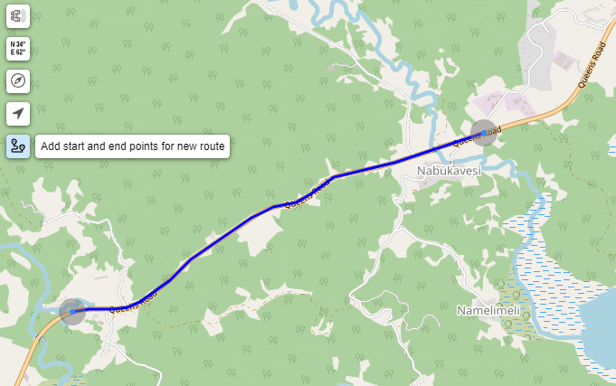
You create a Route using the Find Routes tool

Click and select you start and end points. A route will be created.

Example route

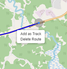
To save the route right-click on the route and select Add as Track

The route creation tool uses the https://maps.openrouteservice.org/ API

PreviousManage tracksNextView in another app

Last updated 1 year ago

Was this helpful?